Tourism in Bangladesh is a slowly developing foreign currency earner. The country has much to attract international and domestic tourists.
Bangladesh as a holiday making land exposes to many flamboyant facets. Its tourist attractions are many folded, which include archaeological sites, historical mosques and monuments, resorts, beaches, picnic spots, forests and tribal people, wildlife of various species. Bangladesh offers ample opportunities to tourists for angling, water skiing, river cruising, hiking, rowing, yachting, sea bathing as well as bringing one in close touch with pristine nature.
In the northern part, comprising the Rajshahi division, there are archaeological sites, including the temple city Puthia in Rajshahi; the largest and most ancient archaeological site, Mahasthangarh in Bogra; the single largest Buddhist monastery, Paharpur in Naogaon; the most ornamental terracota Hindu temple in Bangladesh Kantaji Temple, and many rajbaris or palaces of old zamindars.
In the south-western part, mainly the Khulna Division, there is the Sundarbans, the largest mangrove forest of the world with Royal Bengal Tiger and spotted deer. The historically and architecturally important sixty domed mosque in Bagerhat is a notable site.
In the south-eastern part, which is the Chittagong division, there are mainly natural and hilly scenarios like Chittagong Hill Tracts, along with sandy sea beaches. The most notable beach is the longest unbroken sandy sea beach in the world in Cox's Bazaar.
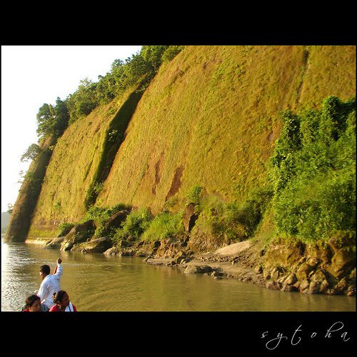
In the north-eastern part, Sylhet division, there is a green carpet of tea plants on small hillocks. Natural reserved forests are great attractions. Migratory birds in winter, particularly in the haor areas, are also very attractive in this area.
In 2004, the US Department of State estimated the daily cost of staying in Dhaka at $191. Expenses in other areas can be much lower.
Saint Martin
 |
saint martin |
Saint Martins Island In Bangladesh is the most beautiful Coral And Nice Island where you will find live corals. Its only 30 km Away from Teknaf Last Port and you can go there by Speed Board, motorboat, Small Ship, tourist boats, And sea truck. This Island Is A Eye Catching And Good Looking Island. Its Have Many Resident Hotel, Motel And Luxery Resort For Living. This Island Famouse For Corals, Coconut Tree And Smallest.
 |
| Beach of saint martin |


 |
| Keya Tree |
 |
| Simana Pariya Resort |
 |
| Saint Martin |
Cox's Bazar District is a district in the Chittagong Division of Bangladesh. It is named after Cox's Bazar, which is one of the world's longest natural sea beaches (120 kilometres (75 mi) including mud flats). It is located 150 kilometres (93 mi) south of Chittagong. Cox's Bazar is also known by the name Panowa ("yellow flower"). Another old name was Palongkee. The modern Cox's Bazar derives its name from Captain Cox (died 1798), an army officer who served in British India. It is one of the fishing ports of Bangladesh.
 |
| Cox's Bazar |
The name Cox's Bazar/Bazaar derived from the name of Captain James Cox of the East India, who was in charge of the naval base. In 1854, Cox's Bazar was made a subdivisional headquarters.
After the end of British rule, Cox's Bazar remained part of East Pakistan. Captain Advocate Fazlul Karim was the first chairman after independence from the British of Cox's Bazar municipality. He established the Tamarisk Forest along the beach to draw tourism to the town and to protect the beach from the tide. He donated many of his father-in-law's and his own lands to establish a public library and town hall. In 1971, the wharf was used as a naval port by the Pakistan Navy's gunboats. This and the nearby airstrip of the Pakistan Air Force were the scene of intense shelling by the Indian Navy during the Bangladesh Liberation War in 1971.
In 1984 Cox's Bazar was made a District.
 |
| Cox's bazar Sunset |
Bandarban

 |
| Fishing on the lake |
In the early days of 15th century, Arakanese kingdom, where Mrauk U was the capital, expended its territories to the Chittagong area of Bengal. After the victory of Arakan on Burma's Pegu kingdom in 1599 AD, the Arakanese king Mong Raja Gree appointed a Prince of Pegu as the governor of newly established Bohmong Htaung (Circle) by giving the title of "Bohmong" Raja. That area was mostly populated by the Arakanese descendants and ruled by the Burmese (Myanmar) noble descendants who started to call themselves in Arakanese language as Marma. Marma is an archaic Arakanese pronunciation for Myanmar. As the population of the Bohmong Htaung were of Arakanese descandants, these Myanmar-descendants Bohmong chiefs (Rajas) of the ruling class took the titles in Arakanese and speak a dialect of the Arakanese language.
 |
| Tindu, Bandarban |
 |
| Tindu |
Bandarban Hill District was once called Bohmong Htaung since the Arakanese rule. Once Bohmong Htaung was ruled by Bohmong Rajas who were the subordinates to the Arakanese kings. Ancestors of the present Bohmong dynasty were the successor of the Pegu King of Burma under the Arakan's rule in Chittagong. In 1614, King Mong Kha Maung, the king of Arakan appointed Maung Saw Pru as Governor of Chittagong who in 1620 repulsed the Portuguese invasion with great valour. As a consequence, Arakanese king, Mong Kha Maung adorned Maung Saw Pru with a title of Bohmong meaning Great General. After the death of Maung Saw Pru two successors retained Bohmong title. During the time of Bohmong Hari Gneo in 1710, Arakanese King Canda Wizaya recaptured Chittagong from the Mughals. Bohmong Hari Gneo helped King Canda Wizaya in recapturing Chittagong and as a mark of gratitude the later conferred on Bohmong Hari Gneo the grand title of Bohmong Gree which means great Commander in Chief.
 |
| Bandarbon lake |
 |
| The Lake boga, Bandarbon |
 |
| pukur para jhorna, Bandarban |
Bangladesh is a land of beauty, and it is blessed with boundless natural objects. Pukurpara Waterfall is just one from that list. This country has several waterfalls scattered all around. But the waterfall that I'm going to introduce with you is a bit different than those. Interestingly the waterfall is located at the Bilaichhori Thana of Rangamati district. But to have an access to the waterfall, you need to use the trekking routes from Bandarban. It is just few hundreds meter apart from the Bandarban district's border. This waterfall is currently the widest waterfall from Bangladesh. It has a width of approximately 80 meters and the height of 4-6 feet on an average. During the rainy season, you will not be able to see any stones from the waterfall. Only visible are the cascades of water. Some people used to call this as the "Niagara of Bangladesh". After the waterfall, it as possibly a several hundred feet of down stream over solid rock(almost like a road of concretes), and over that rock, water from the fall is flowing downwards with a huge force. If you walk normally beside the stream, it will possibly take 40-50 minutes to reach at the bottom of the waterfall stream. Except the rainy season, the path is in good condition. But during rainy season, you can only risk your life if you attempt to go down over those slippy path. This waterfall is created from the water of Raikhong Canal and the water finally goes to the great Kaptai Lake. Some people used to call this Raikhong River. According to the name of the Canal/River, some people used to call this waterfall as Raikhong Waterfall. For your information, it is called PukurPara Waterfall, because there is a village near the waterfall named Pukur Para. Trekkers used to make a shelter at Pukurpara village, and only visits the waterfall for few hours. But if you make your trip a bit wisely, you can set few tents around the waterfall during summer or winter for nighttime stay. There are numerous dry and clean places around the waterfall for your camping. But unfortunately almost no one used to do that. Just wonder how it will feel when you are sleeping beside a waterfall at night. Bonus when it will be a full moon, or a night full of starts at null moon.
 |
| Sarnomondir Bandarban |


Rangamati
Rangamati is a district in South-eastern Bangladesh. It is a part of the Chittagong Hill Tracts and the town of Rangamati serves as the headquarters of the district. Area-wise, Rangamati is the largest district of the country.
 |
| Rangamati Hill's are standing on the lake side. |
From Chittagong a 77 km road amidst green fields and winding hills leads to Rangamati; which is a wonderful repository of scenic splendours with flora and fauna of varied descriptions. The township is located on the western bank of the Kaptai lake. Rangamati is a favourite holiday destination because of its beautiful landscape, scenic beauty, lake, colourful indigenus groups (Chakma, Marma etc), its flora and fauna, indigenous museum, hanging bridge, homespun textile products, ivory jewellery and the indigenous men and women who fashion them. For tourists, the attractions of Rangamati are numerous. Indigenous life, fishing, speed boat cruising, hiking, bathing or merely enjoying nature as it is.

History
Construction of the reservoir for the hydro-electric plant began in 1956 by the Government of East Pakistan.As a result, 54,000 acres (220 km2) of farmland in the Rangamati District went under water and created the lake.
The hydro-electric project was funded by the United States. The project was finished in 1962. International Engineering Company and Utah International Inc. received the contract for construction of the dam. The dam is 670.6 meters long, and 54.7 meters high. The dam has a 745 feet (227 m) long spillway containing 16 gates. Through the spillway 5,250,000 cu ft/s (149,000 m3/s) of water can pass.
The land that went under water as a result of the dam construction, was 40% of the total arable land in the area. Along with that, 29 square miles (75 km2) of the Government-owned forest, and 234 square miles (610 km2) of other forest land went under water. About 18,000 families with a total of almost 100 thousand people were also displaced. The palace of the king of the Chakmas was also flooded and is now under water.


Hanging Bridge: Hanging Bridge(Jhulonto Bridge in Bengali)is the landmark icon of Rangamati. It's a popular tourist spot and a must go destination.
Kaptai Lake : Kaptai lake is a wonderful spot for boating and cruising. Parjatan and private tour operators offer a number of cruises by mechanical boats. One can go to various scenic spots in Shuvalong, Barkal, Longadu, Mainimukh and other areas by boat from Rangamati.
Indigenous Museum : The only Indigenous Cultural Museum in the Chittagong Hill Tracts region was established at Rangamati town in 1978 and run by the Tribal Cultural Institute. It preserves valuable objects and articles of different tribes depicting their socio-economic, cultural and historical tradition. These include typical indigenous dresses, ornaments, arms and ammunitions, coins, statues made of wood, bronze and other metals, musical instruments, ivory products, handicrafts, paintings on tribal life etc.
Open: Saturday- Thursday, 10.00 a.m.- 4.00 p.m. Closed: Friday & Public Holidys. Admission is free.
Sundarban
 |
| Sundarbans National Park |
In 1911, it was described as a tract of waste country which had never been surveyed, nor had the census been extended to it. It then stretched for about 165 miles (266 km) from the mouth of the Hugli to the mouth of the Meghna, and was bordered inland by the three settled districts of the Twenty-four Parganas, Khulna and Backergunje. The total area (including water) was estimated at 6,526 square miles (16,902 km2).
The present Sundarbans National Park was declared as the core area of Sundarbans Tiger Reserve in 1973 and a wildlife sanctuary in 1977. On May 4, 1984 it was declared a National Park. It was inscribed on the UNESCO World Heritage list in 1987. Whole Sundarbans area was declared as Biosphere Reserve in 1989. Now days, This forest is nominated for the New 7 Natural Wonders of the World


 | ||||||||||||||||||||||||||||||||||||||||||||||||||||||||||||||||||||||||
| Sundari tree |
The Bangladesh mangrove vegetation of the Sundarbans differs greatly from other non-deltaic coastal mangrove forests and upland forests associations. Unlike the former, the Rhizophoraceae are of minor importance. Differences in vegetation have been explained in terms of freshwater and low salinity influences in the Northeast and variations in drainage and siltation. The Sundarbans has been classified as a moist tropical forest demonstrating a whole mosaic of seres, comprising primary colonization on new accretions to more mature beach forests, often conspicuously dominated by Keora (Sonneratia apetala) and tidal forests. Historically three principal vegetation types have been recognized in broad correlation with varying degrees of water salinity, freshwater flushing and physiography and which are represented in the wildlife sanctuaries:
Sundari and Gewa occur prominently throughout the area with discontinuous distribution of Dhundul (Xylocarpus granatum) and Kankra. Among grasses and Palms, Poresia coaractata, Myriostachya wightiana, Imperata cylindrica, Phragmites karka, Nypa fruticans are well distributed. Keora is an indicator species for newly accreted mudbanks and is an important species for wildlife, especially spotted deer (Axis axis). Besides the forest, there are extensive areas of brackish and freshwater marshes, intertidal mudflats, sandflats, sand dunes with typical dune vegetation, open grassland on sandy soils and raised areas supporting a variety of terrestrial shrubs and trees.
 |
| A Royal Bengal tiger in Sundarban |
There is much more wildlife here than just the endangered Royal Bengal Tiger (Panthera tigris tigris). Most importantly, mangroves are a transition from the marine to freshwater and terrestrial systems, and provide critical habitat for numerous species of small fish, crabs, fidler crabs, hermit crabs, shrimps and other crustaceans that adapt to feed and shelter, and reproduce among the tangled mass of roots, known as pneumatophores, which grow upward from the anaerobic mud to get the supply of oxygen. Fishing Cats, Macaques, wild boars, Common Grey Mongooses, Foxes, Jungle Cats, Flying Foxes, Pangolins, and spotted deer are also found in abundance in the Sundarbans.
A 1991 study has revealed that the Bangladeshi part of the Sundarbans supports diverse biological resources including at least 150 species of commercially important fishes, 270 species of birds, 42 species of mammals, 35 reptiles and 8 amphibian species. This represents a significant proportion of the species present in Bangladesh (i.e. about 30% of the reptiles, 37% the birds and 34% of the mammals) and includes a large number of species which are now extinct elsewhere in the country.Two amphibians, 14 reptiles, 25 aves and five mammals are presently endangered. The Sundarbans is an important wintering area for migrant water birds and is an area suitable for watching and studying avifauna.
 |
| Chital deer are widely seen in southern parts of Sundarban |

 Climate change impact: he physical development processes along the coast are influenced by a multitude of factors, comprising wave motions, micro and macro-tidal cycles and long shore currents typical to the coastal tract. The shore currents vary greatly along with the monsoon. These are also affected by cyclonic action. Erosion and accretion through these forces maintains varying levels, as yet not properly measured, of physiographic change whilst the mangrove vegetation itself provides a remarkable stability to the entire system. During each monsoon season almost all the Bengal Delta is submerged, much of it for half a year. The sediment of the lower delta plain is primarily advected inland by monsoonal coastal setup and cyclonic events. One of the greatest challenges people living on the Ganges Delta may face in coming years is the threat of rising sea levels caused mostly by subsidence in the region and partly by climate change.
 Sylhet
 |
| Tea garden |
Sylhet Division (Bengali: pronounced Sileṭ Bibhag), also known as Greater Sylhet or Sylhet region, is the northeastern division of Bangladesh, named after its main city, Sylhet. It is bounded by Meghalaya State of India on the north, Tripura State on the south, Assam State of India on the east and Dhaka division on the west and Chittagong division on the southwest.
One of the most picturesque and archeologically rich regions in South Asia, is the Sylhet Division. Its bourgeoning economy has become a part of the attractions of the region, as landscapes are filled with fragrant orange and pineapple gardens and breathtaking tea plantations. Many Sylhet community members have found work and residence abroad, particularly in the United Kingdom and have been using remittances to fund projects and industries within the Sylhet Division, allowing the export industry and foreign investment sectors to grow.
Fotikchori
 | ||
| Paddy field |